OLYMPIA – The Washington state Department of Natural Resources released new maps to show the fastest routes to safety for coastal communities in the event of an incoming tsunami.
The evacuation maps, made by the DNR’s Washington Geological Survey, show pedestrian routes for Port Townsend, Ilwaco, Long Beach and Seaview, and Westport.
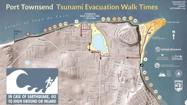
They also show the times it would take to evacuate the tsunami inundations zones caused by a Cascadia subduction zone earthquake, assuming a slow walking pace of two-and-a-half miles per hour.
These maps are modeled on a magnitude 9 Cascadia earthquake.
The walk times differ for communities based on the topography, but in Port Townsend, for example, where the estimated wave arrival time is 1 hour and 30 minutes, the evacuation time to walk to high ground averages well under 30 minutes.
You can get more information about impacts from earthquakes to Washington communities on DNR’s Geologic Information Portal.