 ABC NewsBy MAX GOLEMBO, ABC News
(NEW YORK) — Severe storms moved through the Southeast Tuesday, which brought baseball size-hail, damaging winds and deadly lightning to South Carolina, where one person died due to the storms.
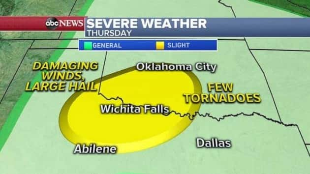
Now a new storm is moving out of the Rockies and into the Plains, where severe weather is in the forecast for Thursday. Damaging winds and hail will be the biggest threat, but an isolated tornado can’t be ruled out.
This same storm system will move east and will bring rain and even snow to the Northeast by Friday night.
A European model keeps the snow further inland, but some other models bring the snow closer to the coast, including the I-95 corridor on Friday night.
Chilly air for this time of year is in the forecast for the Great Lakes, Midwest and the Northeast for Mother’s Day weekend.
Some wind chills will be in the 20s and 30s from Nashville, Tennessee to New York City.
While freezing wind chills move across the Plains and Northeast, record heat continues for the Southwest.
There are several record highs possible Wednesday in the Southwest, from Southern California to Arizona.
Records are possible Wednesday in Phoenix (106), Yuma, Arizona (107), and Palm Springs, California (108.)
Numerous heat watches, warnings and advisories have been issued for Wednesday from California to Nevada to Arizona.
A heat advisory was also issued for Los Angeles, where temperatures will be in the 90s Wednesday.
The record heat will continue over the next several days in the region, but a slight cool down is forecast by Friday.
Copyright © 2020, ABC Audio. All rights reserved.