 ABC NewsBy DANIEL MANZO, ABC News
(NEW YORK) — After a relatively quiet Thanksgiving across much of the U.S., the weather pattern is about to turn quite turbulent in the coming days.
A new storm system is going to develop this weekend and track across the Southern and Eastern U.S. bringing multiple hazards, including heavy rain, strong thunderstorms, damaging winds and some snow.
The first impacts of the storm will be Friday with some strong thunderstorms forming near Southeast Texas.
On Saturday, the storm will start to get more organized with heavy rain moving onshore to Southern Texas and New Orleans where localized flooding will be possible.
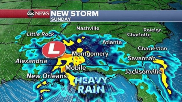
On Sunday, the storm will be moving through the Gulf States and heavy rain will spread over much of the South from Louisiana to the Carolinas.
Once again localized flooding and some occasional strong thunderstorms with gusty winds will be possible, especially from New Orleans to Raleigh, North Carolina.
On Monday, as the storm travels up the eastern U.S., it will be invigorated by a cold shot of air coming in from the Midwest and the storm will strengthen somewhere over the Appalachians.
The result on the milder eastern side of the storm will be widespread with very heavy rainfall. Additionally, some very strong winds will have the potential to mix down from aloft, especially across New England which could result in some potential for damaging wind gusts, including power outages.
On the colder side of the storm, precipitation will be falling as snow in parts of Ohio and with the heaviest snow likely to be near the Great Lakes.
It remains too early to determine the precise location of the heaviest snow because it will be determined by the precise location of the strengthening storm.
The main global forecast models are indicating that the storm will be a little slow to move out of the region as it moves into southern Canada on Tuesday and Wednesday but the good news is that the storm should weaken during this time period.
The storm will help pull a shot of cold air across much of the central and eastern U.S. with wind chills in the teens expected from Minnesota possibly into parts of Alabama and Georgia by Tuesday morning.
The most notable part of this cold blast is how far south the cold air will reach and it looks like even parts of northern Florida will be feeling like the low 30s on Tuesday morning.
Meanwhile in the Southwest, another day of dry Santa Ana winds is expected.
On Thanksgiving, the highest elevations outside Los Angeles saw gusts to 75 mph and we are expecting gusts again Friday to possibly reach 75 mph with relative humidity is expected to be as low as 5%.
The gusty winds and the dry air could cause rapid fire spread through the region possibly causing critical fire conditions Friday.
The core of this threat is expected Friday but there will likely be some lingering fire danger into Saturday.
Copyright © 2020, ABC Audio. All rights reserved.